Information
- Mr. Kohsuke Kawakami received the Student Presentation Award (Aurora Medal) at the SGEPSS 2024 Fall meeting.
- Ms. Harune Sekido received the Gold Student Poster Award at ISSS-15 and IPELS-16 conference.
- Mr. Takuya Ijuin received the Outstading Student Presentation Award at the Japan Geoscience Union (JpGU) Meeting 2024.
- Ms. Harune Sekido received the Outstading Student Presentation Award at the Japan Geoscience Union (JpGU) Meeting 2024.
- Mr. Hayato Higuchi received the Student Presentation Excellence Award at the Kyushu University Quantum Native Development and Research Symposium.
- Ms. Moe Hayashi is awarded GEM Student Poster Competition Winners.
- Ms. Harune Sekido received the Student Presentation Award at the SGEPSS 2023 Fall meeting.
- Ms. Moe Hayashi received the Student Presentation Award at the SGEPSS 2023 Fall meeting.
Announcement of Opportunity
Program Purpose
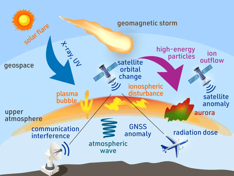
The space around the Earth (geospace), including the upper atmosphere, is highly dynamic. This is due to ultraviolet and X-ray radiation from the Sun, magnetic storms caused by high-energy plasma particles from solar explosions, and atmospheric waves from the lower atmosphere. These geospace variations affect radio communications between satellites and the ground, causing satellite positioning and communication failures. Magnetic storms also cause the atmosphere to heat and expand resulting in alteration of satellites’ orbits. In addition, high-energy plasma particles from solar explosions and magnetic storms cause radiation hazards to astronauts, satellites, and aircraft crews. As humanity’s use of space continues to increase, understanding and predicting these geospace variabilities have become an urgent issue.
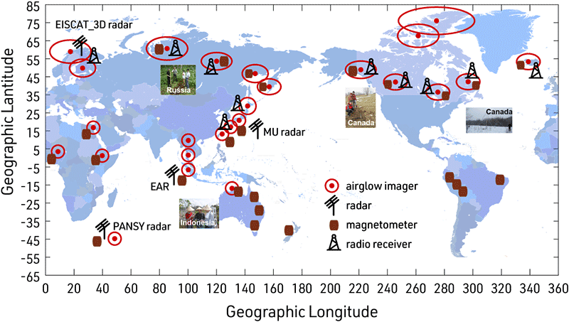
To understand the mechanism behind geospace variability, it is necessary to combine ground instruments and satellites. This allows for comprehensive measurements of geospace. Furthermore, there is also a need to coordinate with modeling through numerical simulations to complement sparse observations and for quantitative evaluations, including space weather prediction. The PBASE program aims to significantly contribute to understanding and predicting geospace variabilities by combining ground-based and satellite observations and modeling, covering a wide area in both altitude and latitude/longitude directions.
Research Method
To understand the mechanism behind geospace variability, it is necessary to combine ground instruments and satellites. This allows for comprehensive measurements of geospace. Furthermore, there is also a need to coordinate with modeling through numerical simulations to complement sparse observations and for quantitative evaluations, including space weather prediction. The PBASE program aims to significantly contribute to understanding and predicting geospace variabilities by combining ground-based and satellite observations and modeling, covering a wide area in both altitude and latitude/longitude directions.
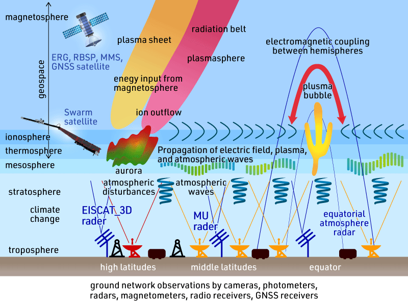
The Japanese members belonging to Nagoya, Kyoto and Kyushu Universities, and the National Institute of Polar Research (NIPR) operate comprehensive ground-based measurements. This team has already been identified as a top-level research group in Japan by the Science Council of Japan and the Ministry (MEXT) in the study of the solar-terrestrial coupling system including geospace. The international joint researchers (overseas Co-Is) are top-level scientists in satellite measurements and modeling, i.e., ionospheric satellites (Swarm) through Prof. Claudia Stolle (Germany) and geospace exploration satellites (RBSP, MMS, FAST, and Cluster) through Prof. Lynn Kistler (USA). Coordination will also be made to include modeling based on TIEGCM through Dr. Gang Lu (USA) and on the kinetic ring current-atmosphere interactions model, jointly developed by Japan and the USA.
International Capacity Building
Early-career researchers including newly hired Post-Doctoral Fellows and Ph.D students are participating in this program. All these students and early career scientists will be promoting research focusing on ground-based observation and modeling. They will stay overseas Co-I’s institutes to compare their own ground observations and modeling, with satellite observations/modeling. This experience will let them develop broad research skills to approach scientific topics using different methods. We also support their field trips for their experience of ground-based measurements. We also invite overseas students and early-career scientists to stay in Japan for 3 months for collaborative research.
Oversea Stays and Trips
FY2023 FY2024 FY2025Oversea and domestic field trips
FY2023 FY2024 FY2025Implementation Procedures
(Measurements and Database)
1. Ground observations
2. Satellite observations
3. Modelling
4. Database and analysis tools
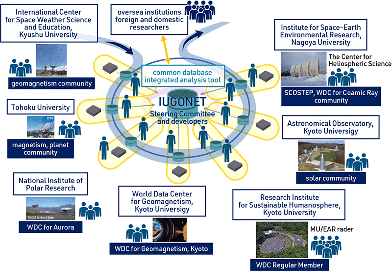
The data obtained by this program will be shared with world communities via IUGONET and ESG Science Center to stimulate international collaborative research.
Schedule
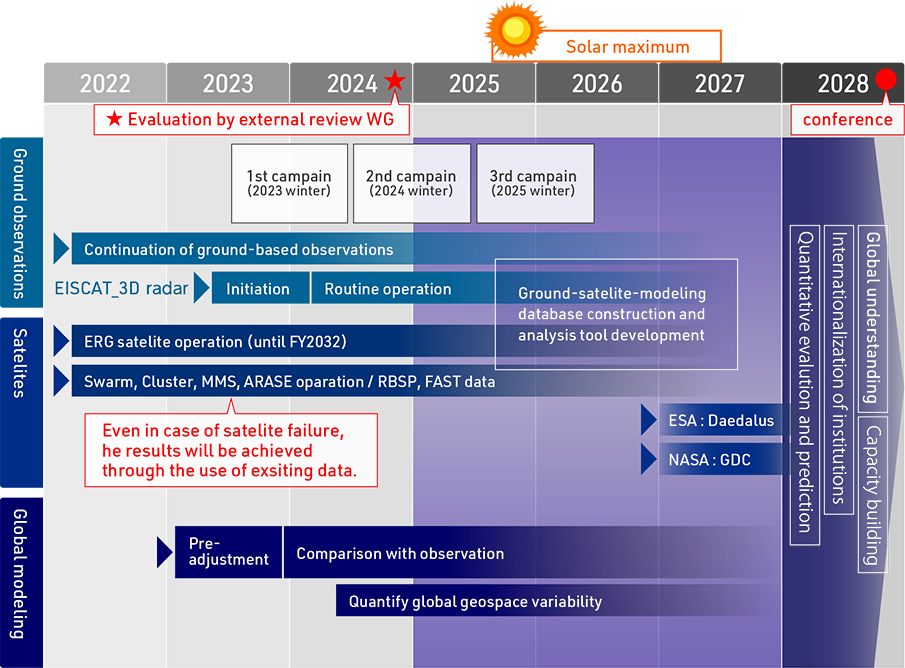
This program was adopted in December 2022 and is planned for seven years from FY2022 to FY2028. The EISCAT_3D radar will start operation in the first half of 2023. Intensive campaign observations will be conducted in the winter of the second and third years when the radar starts operating, and in the winter of 2025 when the solar activity is expected to reach a maximum. A group of satellites has already been launched and is still in operation. In the event of failure of these satellites, the results will be achieved through the use of observation data and collaboration with other satellites. The global model will be pre-tuned over the next year, and then validated and refined through comparison with observations to reproduce and quantify global geospatial variability. We will continue to build a common ground-satellite-modelling database and develop tools for integrated analysis of all data.
Members
Principal Investigator
SHIOKAWA, Kazuo Professor, Nagoya University
Completed the master’s course of the special study of geophysics of the Graduate School of Science of Tohoku University in 1990, becoming a Research Associate of the Solar-Terrestrial Environment Laboratory (currenty,Institute for Space-Earth Environmental Research (ISEE)), Nagoya University in 1990, a visiting researcher of the Max-Planck Institute for extraterrestrial Physics, Germany from 1996 to 1997, an assistant professor of Nagoya University in 1999, and staying in the current post from 2008. Prof. Shiokawa’s speciality is the observational research of space around the earth by the optical observation and electromagnetic field measurement of aurora and nightglow.Serving as co-chair of the SCOSTEP’s VarSITI (Variability of the Sun and Its Terrestrial Impact) program for 2014-2018 and SCOSTEP President after 2019. In this program, he wil supervise the project, ground measurements, and coordination with satellites and modeling.
Co-Investigators
MIYOSHI, YoshizumiProfessor, Nagoya University
ERG satellite and ground measurements, radiation belts modeling, and analysis tool development
OGAWA, YasunobuProfessor, National Institute of Polar Research
EISCAT_3D radar measurement and coordination with satellites and modeling
YOKOYAMA, TatsuhiroAssociate Professor, Kyoto University
MU and Equatorial Atmosphere radar measurement and coordination with satellites and modeling
YOSHIKAWA, AkimasaProfessor, Kyushu University
Ground electromagnetic measurement and coordination with satellites and modeling
HSIEH, YikaiJunior Associate Professor, Kyoto University
Simulations of magnetospheric and upper atmospheric energetic particles and coordination with satellites and modeling
LIU, HuixinProfessor, Kyushu University
ionospheric satellites and coordination with ground measurements and modeling
MARTINEZ-CALDERON, ClaudiaAssociate Professor, Nagoya University
Satellite and ground observations and modeling of generation and propagation of ELF/VLF electromagnetic waves
Overseas Co-Investigators
KISTLER, LynnUniversity of New Hampshire (UNH), USA
coordination with magnetospheric satellites, such as Van Allen Probes, MMS, and Cluster
LU, GangHigh Altitude Observatory (HAO), USA
Coordination with modeling of the upper atmosphere, such as MAGE/TIEGCM modeling
STOLLE, ClaudiaLeibniz Institute of Atmospheric Physics (IAP), Germany
Coordination with ionospheric satellites, such as Swarm, and ground-based observations of IAP
Research collaborators (faculty staff)
OTSUKA, YuichiAssociate Professor, Nagoya University
GNSS measurements and database constructions
NISHITANI, NozomuAssociate Professor, Nagoya University
SuperDARN HF radar measurements
NOSE, MasahitoProfessor, Nagoya City University
magnetometer measurements
OYAMA, Shin-ichiroLecturer, Nagoya University
optical and EISCAT_3D measurements
KATAOKA, RyuhoAssociate Professor, National Institute of Polar Research
Optical and electromagnetic measurements in the polar region
TANAKA, YoshimasaAssociate Professor, National Institute of Polar Research
Optical and electromagnetic measurements in the polar region
YAMAMOTO, MamoruProfessor, Kyoto University
MU and Equatorial Atmosphere radar measurement and coordination with satellites and modeling

